
BIG 926
Presently/Actuellement |
Would be/Serait |
Official name / Dénomination officielle |
Altitude |
OLIGIRTOS (950m) |
DELETED/ELIMINEE |
LIKAVITOS HILL |
198m |
ANALYSE / ANALYSIS
DESCRIPTION
Oligirtos est un massif au nord du massif du Menalon (Mainalon) coupé par une route en lacets dont on peut deviner le sommet sous le g et entre le y et le u de l'écriture grecque.
Oligirtos is a massive at the north of the Mainalon massive (Menalon), crossed by an hairpin road which we can think about the top under the g and between the y and the u of the greek writing.
LOCATION'S DIFFICULTY - DIFFICULTE DE LOCALISATION
Aucun site ne localise précisément le sommet de la route et aucune altitude précise ne sort du lot actuellement.
No website locates precisely the top of the road and no precise height is in evidence until now.
NAME'S DIFFICULTY - DIFFICULTE DE DENOMINATION
Oligirtos est le nom de la chaîne, le sommet n'a pas de nom précis.
Oligirtos is the name of the massive, the top has no precise name.
CHOICE'S DIFFICULTY - DIFFICULTE DE CHOIX
C'est un massif qui n'est pas couvert et une zone assez déserte mais floue, on pourrait trouver autre chose.
It's an uncovered massive and a desertic area for the moment, but it's not clear, we may find something else.
TAKING PLACE's SUGGESTION - SUGGESTION DE REMPLACEMENT
Likavitos Hill
Aux Jeux Olympiques de 2004, la course cycliste sur route empruntait les artères qui s'élevaient sur les flancs du Likavitos hill, la plus haute colline d'Athènes surplombant l'Acropole et le Parthénon. Loin de rejoindre le sommet de la colline, les rues dont on doit vérifier la praticabilité comme les sens interdits éventuels au quotidien, atteignaient toutefois près de 200m d'altitude. Comme en dehors des cols Katara et Langada au Tour de Grèce 2006, nous n'avions aucune ascension médiatique pour le pays, c'est une bonne occasion de faire un petit appel aux souvenirs aux Bettini et Axel Merckx.
At the Olympic Games in 2004, the road cycling race rode the streets climbing the slopes of the Likavitos Hill, the highest hill in Athens dominating the Acropola and the Parthenon. Far to reach the top of the hill, the streets used, which we have to verify the rideability and the eventual daily one-way roads, reach an altitude of nearly 200m. As we haven't many mediatic climbs, except the Katara and Langada Passes in the Greece Tour 2006, it's a good occasion to remeber ourselves the victory of Paolo Bettini and the third place of Axel Merckx.
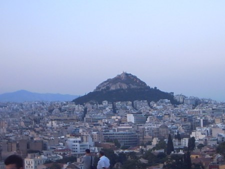
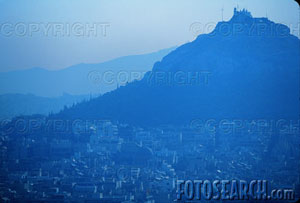
Belles vues du Likavitos Hill - Good views on Likavitos Hill

Il y a des rues sur les flancs de la colline, même une en lacets qui mène au théâtre du sommet. Mais les sites parlent de marcheurs atteignant le sommet par des escaliers ou un téléphérique.
There are streets on the slopes of the hill, even one with hairpins reaching the top, but the websites are talking about walkers reaching the theater on the top through an outdoor staircase.

Voici le circuit olympique. Il contourne la colline et arpente un de ses flancs.
Here is the olympic tour. It surrounds the hill and climbs its sides.
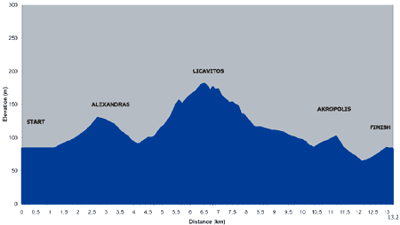
Le graphique officiel montre que ces rues utilisées culminaient à environ 200m.
The official profile shows that the streets used nearly reach 200m over the sea.

Photo rare : des coureurs professionnels sous l'Acropole.
Rare picture : professional racers under the Acropole.
URL