B08
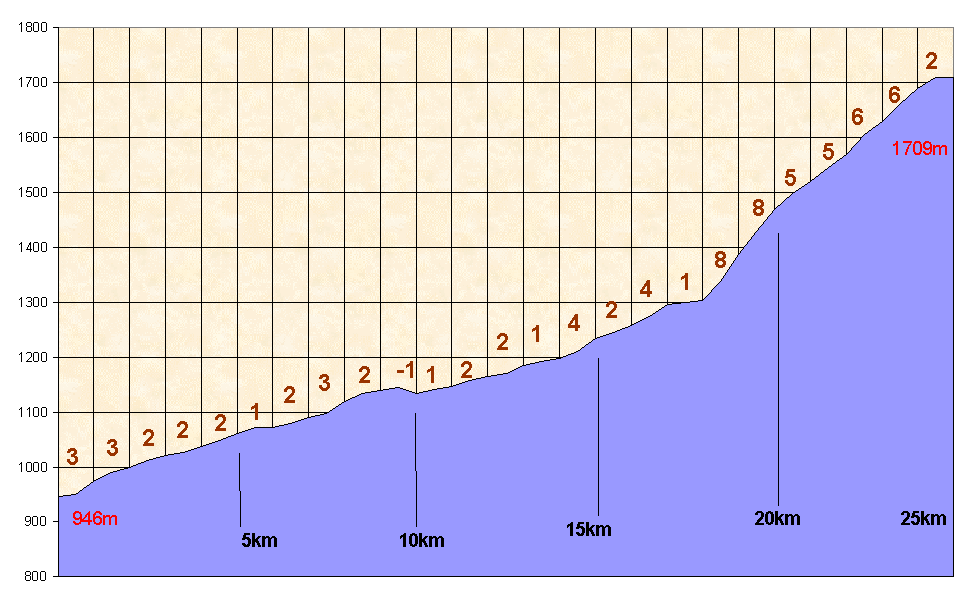
MALJOVICA Komplex-NE1709m
474
Europoints [2d Class] 18,792EuroflashLocalisation - Location
|
Pays/country |
Bulgaria |
|
Province |
Rila Mountains |
|
Latitud pied-foot |
42°11,236' |
|
Longitud pied-foot |
23°39,283' |
|
Village pied / Foot |
Samokov |
|
Latitud sommet-top |
42°05,143' |
|
Longitud sommet-top |
23°33,874' |
|
Road - route |
U |
Versant nord - northern side
La ville de Samokov qui sert de base à l'ascension n'a pas beaucoup d'âme. On la quitte le long d'une vallée qui se traine en traversant les villages de Beli Iskar, puis Govedarci. On serait prêt à mourir d'ennui quand soudain, un virage à gauche, présente face à soi un véritable mur à près de 10%. Tout droit. Le virage suivant n'offre aucun répit et c'est durant 1,5 km qu'on affronte cette pente. Heureusement, après, on récupère des pourcentages moins sévères mais plus montagnards tout de même que le pied. On s'étonne de tomber à un moment sur une douane suiise, qui n'est en fait qu'une barrière signalant le début d'une zone où la croix rouge intervient. Les virages se succèdent aux virages. On hume la station d'hiver à plein nez. On atteint enfin un parking sur la droite qui donne accès aux pistes l'hiver. Le BIG se prolonge toutefois sur la gauche encore durant 500 mètres et aboutit à un cul-de-sac face à un hôtel. De là, il vous est loisible par un petit sentier de retomber sur l'iommense prairie servant de lieu de rassemblement pour les skieurs. On y déguste sans problèmes les spécialités bulgares à la charmante terrasse de la cafétaria avec vue sur toutes le domaine skiable.
Samokov which is the start for this climb hasn't any aim. We leave it through a long valley, going up slowly and poorly, crossing the villages called Beli Iskar and Govedarci. We would be ready to sleep when suddenly, turning to the left, the road shows a real wall in front of us with about 1:10 gradients. Straight along. The following curve is disapointing. No calm. Along one kilometer and a half, this gradient keeps you out of air. But, then, afterwards, the gradients are lower, more mountaineous indeed than in the low valley, but quite normal. We look at the signs of a winter resort. Suddenly, too, we hurt a swiss border. No, it's only a barrier showing the beginning of the area where the red cross (for the health) can help you. We reach a car-park leading to the winter activities'area, but the Big's climb has to be continued for a half kilometer. At the end, it's an end-road in front of an hostel. There, we can go down on a narrow path to the big grass serving as meeting point for winter sports. In the pub, giving you all the best bulgarian meats and drinks, you can observe the whole skiing area.
Me(a)sures GPS : km 0 Pied/foot : 946m - Sommet-top : 1709m
|
0.5 |
1 |
1.5 |
2 |
2.5 |
3 |
3.5 |
4 |
4.5 |
5 |
|
950 |
973 |
990 |
1000 |
1012 |
1021 |
1026 |
1037 |
1048 |
1071 |
|
5.5 |
6 |
6.5 |
7 |
7.5 |
8 |
8.5 |
9 |
9,5 |
10 |
|
1072 |
1073 |
1080 |
1090 |
1097 |
1120 |
1134 |
1140 |
1145 |
1134 |
|
10,5 |
11 |
11,5 |
12 |
12,5 |
13 |
13,5 |
14 |
14,5 |
15 |
|
1141 |
1147 |
1157 |
1164 |
1170 |
1184 |
1193 |
1197 |
1211 |
1234 |
|
15,5 |
16 |
16.5 |
17 |
17.5 |
18 |
18.5 |
19 |
19,5 |
20 |
|
1245 |
1257 |
1274 |
1296 |
1300 |
1304 |
1338 |
1387 |
1428 |
1469 |
|
20,5 |
21 |
21,5 |
22 |
22,5 |
23 |
23,5 |
24 |
24,5 |
25 |
|
1499 |
1520 |
1545 |
1570 |
1605 |
1630 |
1660 |
1690 |
1690 |
1709 |
Graphique - Graphic
Photos / pictures
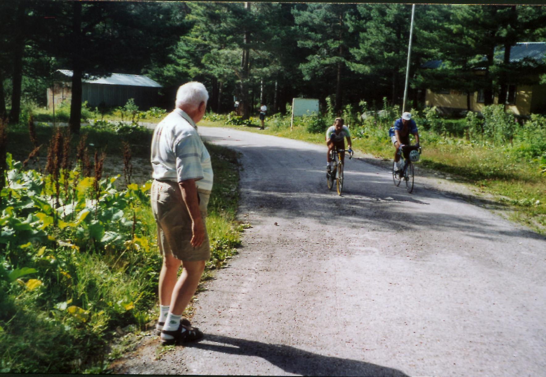
Un demi kilomètre plus haut que la parking de la station, Daniel Gobert et Bernard Giraudeau atteignent le cul-de-sac face au grand hôtel de la station. Samokov est 25km derrrière eux.