 |
 |
 |
médiatique, mediatic |
touristique, touristic |
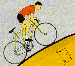
pentes, slopes |
4. IN/IN
|
|
|
médiatique, mediatic |
touristique, touristic |
pentes, slopes |
III.I. Propositions / Suggestions
1- Hamburg - Waseberg (90m) ou Schwarze Berg (127m)
Au nord du Harz, il existe quelques vallées importantes (Elbe, Weser, Werra, …). Pas de quoi en faire une série autonome, mais peut-être simplement élargir la liste vers le nord en intégrant une ascension de l’Elbetal. Suggestion à Hambourg : Schwarze Berg (127m) ou mieux le très classique Waseberg (90m, avec 400m à 13-16%, Hamburg Classic - PRO TOUR)
At the north of the massive Harz, there are few important valleys (Elbe, Weser, Werra,... ). Not to build a full serie, but simply to get the srie longer to the north, by including a climb in Elebe's valley. Suggestion in Haburg : Schwarze Berg (127m) or better, the very classic Waseberg (90m, with 400m at 13-16%, Hamburg Classic - PRO TOUR )
Waseberg
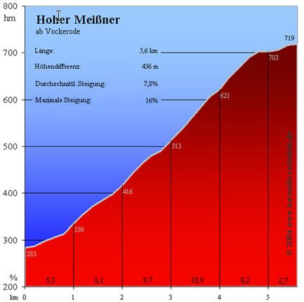
2- Nordhessisches Bergland - Hoher Meißner (719-283m)
Avec le Vogelsberg-Hoherodskopf, le Meißner permet de combler l’axe Francfort-Hannovre, entre le Taunus (au sud), le Harz (au nord), le Sauerland (à l’ouest) et les massifs de Thüringen (à l’est).
Autres avantages : un classique dans la région et un niveau de difficulté correct (5,5km à presque 8%).
With the Vogelsberg-Hoherodskopf, the Meißner gives the opportunity to fill the way Frankfurt-Hannover, between the Taunus (southern), the Harz (northern), the Sauerland (western) and the massives of Thüringen (eastern). Other advantages : a classic climb in the region and a good level of difficulty with some good slopes (5,5km at an average gradient of about 8%)
Hoher Meißner
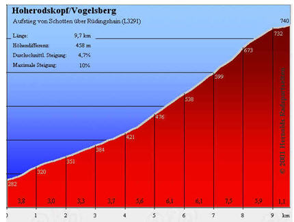
3- Vogelsberg – Hoherodskopf (740-282m en 9km)
Le massif du Vogelsberg se situe au nord-est de Francfort. Il permet d’étoffer le nord de la Hesse (avec le Hoher Meißner).
Autre avantage : l’ascension du Hoherodskopf fait partie du marathon cycliste « Taunus-Vogelsberg Marathon, cfr.
The massive of the Vogelsberg is located at the east-north of Frankfurt. It gives the opportunity to fill the northern side of the Hesse (with the Hoher Meißner)
Other advantage : the climb to the Hoherodskopf is a must in the cycling "cyclesport" marathon "Taunus - Vogelsberg Marathon", see.
http://hernolds-radseiten.de/index.php?%2FRTFDB%2F%3Fgo%3D278).
Vogelsberg – Hoherodskopf
4- Großer Erleshügel (839-445m, de Suhl à Schmiedefeld)
Cette ascension permet de combler le vide du Thüringer Wald et du Frankenwald, entre le Großer Inselsberg (BIG 179, excentré à l’extrême nord-ouest du Thüringer Wald) et les Auersberg et Fichtelberg (BIG 187 et 188) , situés à l’extrême-ouest du Erzgebirge.
This climb gives the opportunity to fill the emptiness of the Thüringer Forest and of the Franken Forest, between the Großer Inselsberg (BIG nr 179, out of zone at the extreme west-northern side of the Thüringer Forest) and the Auersberg and Fichtelberg (BIG nrs 187 & 188), located at the extreme western side of the Erzgebirge.
Großer Erleshügel

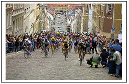
5- Meerane-Steile Wand
Il s’agit, comme son nom l’indique, d’un “ mur abrupt “ de 33 mètres de dénivellation sur 360 mètres pavés. A priori, ridicule. Et pourtant le nombre de pages web qui l’évoquent, avec moult descriptions et photos, traduit l’importance que cette ascension revêtait dans l’ancienne course de la Paix. Le Steile Wand est, comme le Patersberg dans le Tour des Flandres, un classique des classiques. Il est encore très souvent franchi dans le Sachsen-Rundfahrt (Tour de Saxe) et dans le Deutschland-Rundfahrt (Tour d’Allemagne du Pro-Tour 2005).
It's, just as its name shows, a very "steep wall" of 33 meters of difference of level only, but during 360 cobbled meters. Firstlt thought ridiculous, but... the number of web pages about it, with many precise descriptions and pictures, show the importance of this climb in the german cyclerace history, inside the old "Race of the Peace". The "Steile wand" is, just like Paterbeg in the Tour of Flanders, the classic among the classics. It is still often climbed during the tour of Saxe and the more international German Tour (Pro-Tour 2005)
Autre avantage : proche de l’autoroute vers les autres massifs de l’Allemagne de l’est. Aucun détour spécifique, donc.
Other advantage : nea to the motoray leading to the other german montains of the eastern germany. No loss of time, indeed !
Meerane-Steile Wand
6- Erzgebirge-est : Drachenkopf (800m) ou Schwartenberg (788m)
Le massif est représenté par l’Auersberg et le Fichtelberg. Ces deux monts se situent dans la partie ocidentale d’un massif qui se déploie vers le nord-est (vers Dresden). L’est est donc à combler.
The massive is now shown through Auersberg and Fichtelberg. Those two mounts are located in the western area of the mountain which is large to the east-north (to Dresde). The eastern side has to be filled.
Propositions - suggestions : voir - see http://www.leipzig-online.de/dl0kgm/sc/index8.htm
22- Drachenkopf (800-589m)
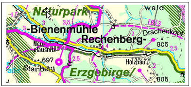
116- Schwartenberg (788-540m de Neuhausen)
Les cartes topographiques du site précité indiquent clairement que le sommet des deux monts est accessible par un chemin revêtu.
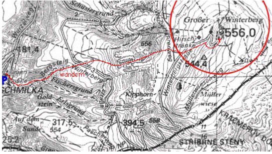
7- Elbsandsteingebirge (Sächsische Schweiz) : Winterbergstraße (552m)
Großer Wintersberg, par la Winterbergstraße (552m-120m+/-), sur la rive droite de l’Elbe, à la frontière tchèque.
Großer Wintersberg, through the Winterbergstraße (552m from about 120m), on the right side of the river Elbe, at the czechian border.
Infos et photos sur http://www.leipzig-online.de/dl0kgm/sc/index8.htm
Winterbergstraße
8- Lausitzergebirge
Plusieurs propositions : voir http://www.leipzig-online.de/dl0kgm/sc/index8.htm et cliquer sur le numéro du mont :
Many suggestions : see http://www.leipzig-online.de/dl0kgm/sc/index8.htm and click the number of the mount :
19- Czorneboh (535m) :
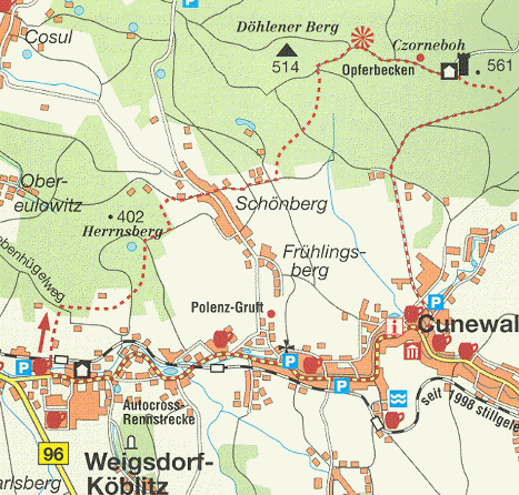
85- Mönchswalder Berg (447m) :
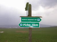
37- Großer Picho (498m) :
Hors du massif, à l’est de Gorlitz - Out of the massive, eastern side of Gorlitz :
73- Landeskrone (420m)
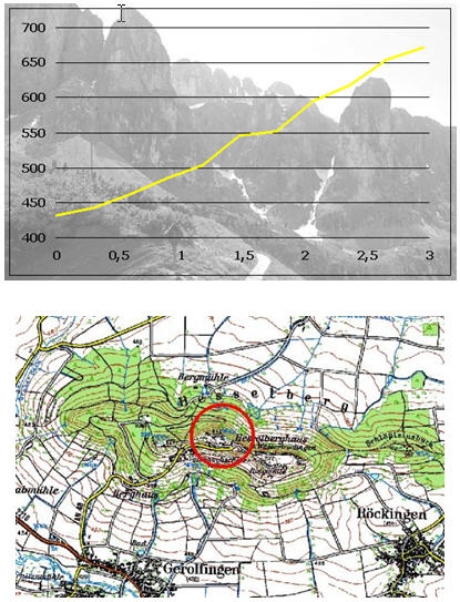
9- Frankische Alb (région de Nürnberg) : Hesselberg (689-440m)
Le centre de la Bavière présente des dénivellations assez réduites. Représenter cette zone revient à accepter une ascension plus faible. A notre connaissance, le Hesselberg peut exercer ce rôle. Il se situe au sud-ouest de Nürnberg, au sud de l’autoroute de Heilbronn (Dinkelsbühl-Gerolfingen).
The center of the Bavarian area shows very poor differences of level. To be the climb for this area doesn't need long slopes. Our knowledge of the field gives this luck to the Hesselberg. It is located at the western south of Nürnberg, at the south of the motorway of Heilbronn (Dinkelsbühl-Gerolfingen).
Hesselberg
10 - Schwäbische Alb - est : Pour l’est de Stuttgart - Furtle paß (630m)
Les cols reconnus ne courent pas les rues hors des massifs allemands et la liste, pour augmenter les dénivellations, privilégie les monts. Il se situe au sud-est de Schwäbisch Gmünd (à l’est de Stuttgart) et permettrait de représenter le Schwäbische Alb.
The official passes of mountains are very rare in Germany and the listing, in the goal to increase the differences of level, gives priority to mounts. This pass is located in the Schwabisch Gmünd (eastern side of Stuttgart) and would give the opportunity to fill the Schwäbische Alb.
Furtle paß
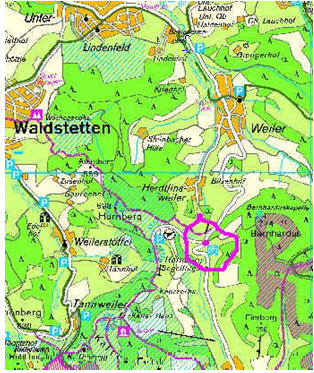
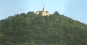
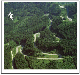
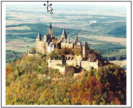
11- Schwäbische Alb - sud : Pour le sud de Stuttgart – Lochen paß (920-550m, Ballingen) ou Hohenzollern schloß (855m).
Avec le Lochen, le BIG comprend un col supplémentaire ; le château du Hohenzollern est un des hauts lieux de l’histoire allemande. Col ou tourisme ?
With the Lochen Pass, the challence countains one more pass of mountain ; the Hohenzollern's castle is one of the high spots of the german history. Pass or tourism ?
Lochen paß (920-550m, Ballingen)
Hohenzollern schloß (855m)
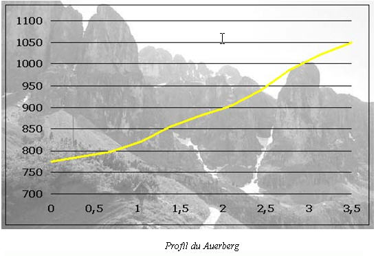
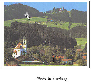
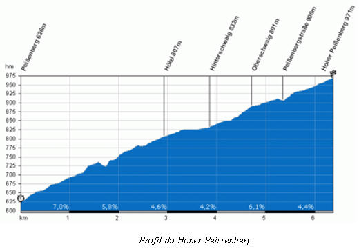
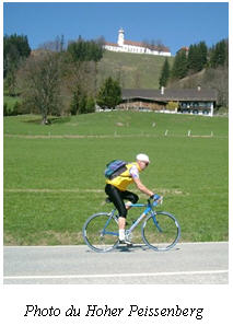
12- Les Préalpes bavaroises (Vorland) : Auerberg ou Grosser Peissenberg
Toutes les ascensions BIG actuelles sont « collées à la frontière austro-allemande. Rien dans les collines des Préalpes (Vorland). Deux monts semblent s’y détacher : Auerberg (1055m) et Hoher Peissenberg (988m).
All the present BIG's climbs are patched to the austrian-german border. Nothing in the hills of the Prealps (Vorland). Two mounts seem to be worth of pain : Auerberg (1005m) and Hoher eissenberg (988m)
Auerberg (1055m)
Hoher Peissenberg (988m).
***************************************************************************************************