A titre indicatif, voici une simulation / As an example, here is a simulation
3. OUT/OUT
II.I. Généralités / Generalities
Alpes bavaroises : réduction de 10 à 7 (mais ajout d’un des Préalpes) - less climbs from 10 to 7 (but one more in the prealps) = -3
Schwarzwald : réduction de 10 à 8 - less climbs from 10 to 8 = -2
Nord-Eifel : réduction de 9 à 5 - less climbs from 7 to 4 = -4
Hunsrück : réduction de 7 à 4 - less climbs from 7 to 4 = -3
Ces réductions permettraient d’intégrer 12 nouvelles ascensions et de présenter une liste plus conforme au relief allemand.
Those decreasings will give the ability to input 12 new climbs and to show a better listing more in accordance with the german landscape.
II.II. Proposition de réduction / Suggestions to decrease
Réduction du Nord - Nord
A bien y réfléchir, est-ce que Hoch Elten (151, à l’est de Nijmegen) a-t-il sa place dans une liste aussi réduite ?
Thinking to the small climb Hoch Elten (nr 151, near Nimegue) : has it really its place among such great climbs ?
 Hoch Elten est une petite butte à la frontière allémano-hollandaise. Certes, un point touristique avec légers pavés mais une dénivellation indigne du relief allemand. Hoch Elten is a small hill at the border Germany-Holland. Of course a touristic spotlight with easy cobbles but such a small difference of level according to the rest of Germany !
Réduction du Schwarzwald - Black Forest
Au nord de Freiburg : 167 et 168 (Hornisgrinde and Schliffkopf) sont deux excroissances de la route des crêtes et ne sont séparées que par un col (Ruhestein). Quel membre a fait les deux ascensions séparément, à partir de la vallée du Rhin ?
At the north of Freiburg : 167 and 168 (Hornisgrinde and Schliffkopf) are two similar climbs and are only separated through a pass called Ruhestein. Which member has really climbed those two BIGs from the feet (Rhine valley) to the tops ?
On garderait / We'll keep 167 or 168 + 169,170
 Venant de Oppenau, au col du Ruhestein, choisir le nord c'est rejoindre le cul-de-sac du Hornisgrinde. Choisir le sud, c'est atteindre l'hôtel du Schliffkopf.
Coming from Oppenau, at the pass called Ruhestein, to choose northern way means to reach the end-road called Hornisgrinde. To choose the southern way means to reach the Schliffkopfhostel.
***********
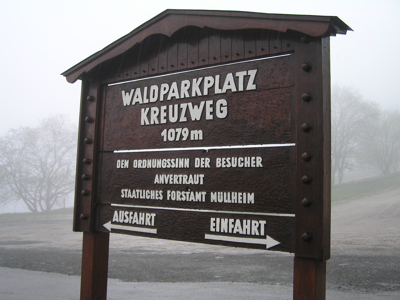
Au sud de Freiburg, il faudrait en éliminer un. Choix difficile. Peut-être Blauen , qui présente des caractéristiques semblables à Belchen ou le Sirnitz, col au nom controversé puisque la plaque indique "Kreuzweg".
At the south of Freiburg, we must delete one of them. Difficult choice. Perhaps one pass between Sirnitz or Weissenbach (Sirnitz has a difficult name because the road-sign on the top shows the name "Kreuzweg", or one end-road between Blauen or Belchen.
On garderait / We'll keep 171-172-173 - 174 or/ou 175-176.
*********
Réduction des Alpes bavaroises
Garder 2 BIG de l’Allgau sur 4 (Nebelhorn et Riedbergpass, par exemple). L'oberjoch est certes beau et frontalier mais un col classique. L'Allgauer est très difficile à localiser. Ces deux-là n'ont aucune commune mesure avec les deux monstres précités dans la parenthèse.
To keep 2 BIGs among 4 in Allgau (Nebelhorn and Riedbergpass seem the better, for instance). Oberjoch Pass is beautiful indeed, but a classic pass. Allgauer is very difficult to locate. Those two climbs haven't any chance compared to the two monsters already written between breakets.
 Les lacets de l'Oberjoch. The curves of the Oberjoch Pass.
 Le Ofterschwang Horn n'est pas facile à trouver. Ofterschwang Horn is very difficult to find.
Eliminer une ascension dans le trio trop concentré (196, 197, 198). Peut-être le Wallberg, moins significatif en difficulté ?
To delete one climb in the too closed three climbs (196, 197, 198). Perhaps Wallberg less significant as a difficulty?
 Wallberg de difficulté moyenne (5km à 7,6%; max:10%) par rapport aux autres à côté, mais paysage bavarois et chapelle au sommet. Wallberg with average difficulty (5km - 7,6%-max : 10%) compared to next climbs, but bavarian landscapes and chapel on the top.
Ajouter un point des Préalpes.
To add one climb in the prealps.
On garderait / We'll keep 192-193-195-196 ou/or 197-198-199-200 + 1 in / en Préalp(e)s.
Réduction de l’Eifel
Supprimer 153 ou 155 (grande proximité et le Mützenich pourrait être considéré comme le prolongement de Am Gericht avec un court replat)
To delete 153 or 155 (great neighbourhood and the Mützenich could be considered as the following part of the "Am gericht" with a small flat area between them)
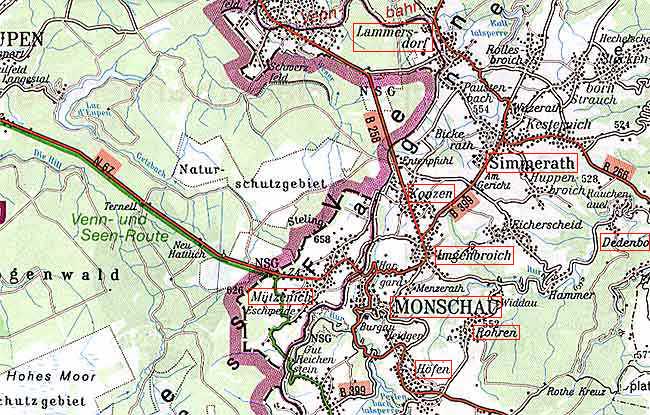 Le versant ouest de Mützenich vient d'Eupen (Belgique) vers l'Allemagne, le versant oriental, quant à lui, pourrait passer par "Am gericht" que vous voyez sous le nom "Simmerath", en utilisant son versant pentu depuis Hammer. Eastern side of Mützenich is coming from Eupen (Belgium) to Germany, the eastern side, would be able to use as a pass-by the "Am Gericht" that you can see just down the name "Simmerath" on the map, using that way its very steep side coming from Hammer.
Supprimer 154 ou 157 (Hohe Acht plus intéressant pour son paysage (Nürbürgring), ses pentes, sa variété et son sommet original avec un sentier étroit et hors trafic). Michelsberg n'est pas très difficile.
To delete 154 or 157 (Hohe Acht seems more interesting for its landscape (Nürbürgring), its slopes, its variety and its special top (pretty narrow road out of traffic)). Michelsberg hasn't a great difficulty.
 Vous prenez la grand-route, puis une petite rue à gauche et vos rejoignez le Michelsberg. Yous ride on the national road, take a narrow street on the left and you reach the chapel of Michelsberg on the top.
Supprimer 158 ou 159 (la Moselle semble incontournable, Krautscheid trop banale ?)
To delete 158 or 159 (the river Moselle must be included, is perhaps Krautscheid too common ?)
 Krautscheid est la route blanche traversant les courbes de niveau très briévement.Krautscheid is the white road crossing the levelcurves but shortly.
On garderait / We'll keep 153 ou/or 155 -156-157-159
Réduction du Hunsrück / Hunsrück
Supprimer 160 ou 161 (Erbeskopf point élevé - 818m). Le Stumpfer Turm vaut beaucoup plus pour le charme de sa ville au pied que pour sa longue route nationale sans pene.
To delete 160 or 161 (Erbeskopf is the highest point - 818m). The Stumpfer Turm is worthy more for its beautiful city on the foot than its long and not steepy national road.
 La route nationale du Stumpfer Turm. Stumpfer Turm's national road.
Supprimer 2 big de 162 à 165 (Donnersberg semble incontournable, Potzberg un peu moins. Cloef pour son tourisme ? Cloef est très bas, mais est touristique pour ses méandres de la Moselle et ses ruines. mais Schaumberg et ses pavés n'est pas mal)
To delete 2 BIGs from 162 to 165 ( Donnersberg is a must, Potzberg a little less. Cloef for tourism ? . Cloef is very low but a real attracton with the curves of the Mosel river and the ruins. but Schaumberg and its cobbles is also worth of pain)
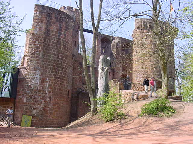 Les ruines du Cloef. Cloef's ruins.
 Le sommet isolé du Potzberg. The lonely top of Potzberg.
On garderait / We'll keep 161-162 ou/or 163 - 165-166.
****************************************************************************