 BIG N°207
BIG N°207
Mûr-de-Bretagne
climb of 6th class - ascension de 6ième catégorie

Le mûr mur de la pente
| SUD-SOUTH | NORD-NORTH | |||
| Altitude | 292m |
Altitude | 292m |
|
| Pied/Foot | 124m |
Pied/Foot | 200m |
|
| Diff.level/dénivel. | 168m |
Diff.level/dénivel. | 92m |
|
| average % moyen | 4,1% |
average % moyen | 5,4% |
|
| maximum % | 15% |
maximum % | 10% |
|
| Length / Longueur | 4,1km |
Length / Longueur | 1,7km |
|
| EUROPOINTS | 189,5 |
EUROPOINTS | 72,1 |
|
| EUROFLASH | 20,993 |
EUROFLASH | 16,133 |
1. General Description générale
Une nationale qui s'envole à perte de vue au sortir de la ville et d'un carrefour à quatre-bras. Une rampe à 15% droite comme un fil tendu vers le sommet et des ondulations chercheuses pour éviter l'antenne sommitale. Mûr était-il un nom prédestiné. On me l'a mûr-mur-é.
A national road going up to the sky just on the exit of a city and after a crossroad with four arms. A steep 15% wall straight like a bended arrow to the top and the searching toboggan at the end to avoid the TV tower. Mûr is the mane and it's near the translation of wall. Destiny ?
Journal de bord
Voiture garée au carrefour vers 15h le dimanche afin de regagner la ville en contrebas et de réattaquer le tout en faisant demi-tour dans la rue de Pontivy (D18). On poursuit avec la rue Le Cerf et on continue à gauche cette D757 nommée alors rue Sainte-Suzanne qui grimpe par paliers avant de plonger vers le carrefour à 4 bras où dort la voiture. Je traverse et ça commence. La route est droite, infiniment droite et exponentielle. Lorsque le 15% est là on le sait à cause du coup de pédale qui est freiné mais le pourcentage est caché dans cette montée sans virages. Premier faux sommet. Encore un casse-patte et un final qui se traîne. En face, c'est plus court et un rien moins pentu mais ça tombe bien pour finir en bas dans les arbres.
Diary
Car parked near the crossroad at 15 o'clock the sunday in the goal to go back down the city. Switchbach in the "Pontivy street" (D18), followed by the "street Le Cerf" (D757), which turns to the left changing its name to "street Sint-Suzanna". It climbs unregularly and when the first top is reached, the downhill is steep to the crossroad where our car lies. Cross and slowly attack of the real climb, slowly but surely, the gradient increases. The 15% is ther, showed thr difficulty to move the legs but hidden inside this road without any curves. First wrong summit. Afterwards, a new short wall and the final section lost around the top. The downhill on the other side is less steep but as steep to be remarkable, with a foot under the trees.

Ce site est l'un des plus beaux de la Bretagne intérieure. Le lac artificiel de Guerlédan, de 400 hectares, s'étend sur 12 km entre Mur-de-Bretagne et Gouarec. Créé en 1930 avec le barrage hydroélectrique de Guerlédan, cette étendue d'eau se niche dans la forêt de Quénécan, un massif forestier de 4 000 hectares. La pratique de la pêche, de la voile et du nautisme y est favorisée.
Son intérieur mêle les lambris et un superbe plafond peint du 18ème siècle, dédié à Sainte-Suzanne. Le visiteur peut également observer un curieux trompe-l'œil représentant un orgue.
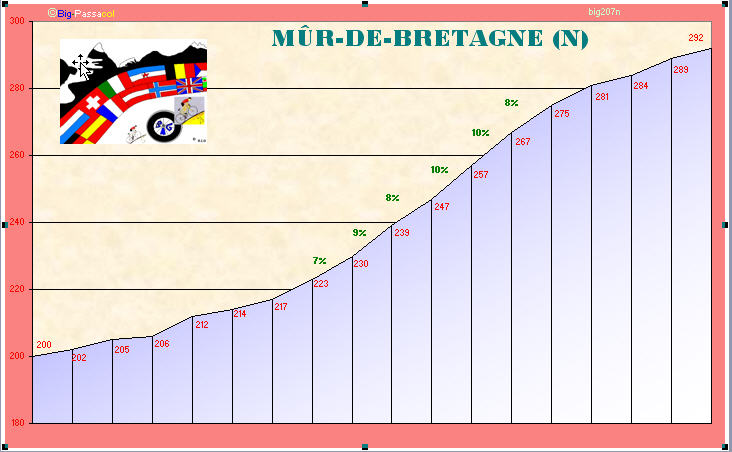
2. Graphique- Grafiek - Profil- Perfil
Il y a une erreur : le premier graphique est le graphique "sud" : le vrai mur de Bretagne. Les pourcentages parlent d'eux-mêmes.
There is a mistake : the first profile give the southern side : the real Wall of Bretagne. The gradients are selffishing to give an idea about the difficulty.

3. Maps - Cartes - Kaarten - Karte - Cartografia
Suivez les chevrons au nord de la ville.
Look at the arrows at the north of the city.

zoom

Google Earth
Vous avez dit "ligne droite" ?
You've said "straight line" ?

4. Photos internet Pictures
5. Photos perso/personal Pictures

La pancarte au sortir de la ville ne peut pas être plus claire
The road-sign at the exit of the city can't be clearer

Et cette vue de face dit tout aussi.
And this view in front of the climb says everything too.

La preuve !
The proof !

Et le sommet se fait attendre. On n'ira pas chercher l'antenne à gauche. Le faux-plat s'étire longuement.
And man is waiting for the real top. The target isn't the TV tower. The flat area is a little long.