 BIG N°210
BIG N°210
Mont Dol
Climb of 8th class - Ascension de 8ième catégorie

Juste un Baby Dol
| Altitude | 65m |
| Pied/Foot | 23m |
| Diff.level/dénivel. | 42m |
| average % moyen | 7,0% |
| maximum % | 18% |
| Length / Longueur | 0,6km |
| EUROPOINTS | 52,6 |
| EUROFLASH | 25,526 |
1. General Description générale
On pourrait bien entendre des DOLéances sur la briéveté de l'effort, pourtant ce baby DOL offre un superbe passage en pente dans la ruelle qui jouxte la boulangerie du village de "Mont Dol". On peut donc sans conteste encourager son nid, DOL !
Man can make some critics about such a short climb, but this Baby DOL has a present : a good steep slope in the narrow road next to the bakery of the village called "Mont Dol". We can now without any hesitation promote this climb. Its name : MOUNT DOL !
Journal de bord
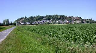
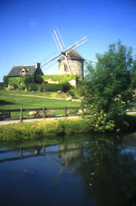
Dimanche 26 février 2006, 9h du mat' Voiture stationnée sur le parking en herbe sous l'église avec des trous attrape-abeilles pour emmêler les cales des chaussures cyclistes. Premiers montages de roues. Jute à gauche du parking en regardant l'église, on peut prendre une ruelle escarpée qui grimpe mais le plus évident est de rejoindre en continuant cette même route le croisement de La Cassière où commence la côte. Vous pouvez repérer ce carrefour. Il est muni à l'intérieur d'une croix en fer et à l'extérieur d'indications multiples dont "bibliothèque" et "mairie". On emprunte alors 350 mètres en légère montée, vers l'église, une légère et courte descente, et à gauche, entre la pâtisserie du village et l'église, on prend une ruelle qui vous emmène vers le haut. Suivre la pancarte "Sommet du Mont Dol". Virage à droite très pentu et 100 m à 18% plus loin encore, la seule épingle à cheveux vers la gauche qui vous entraîne au sommet. A votre droite, une tour. A votre gauch, une croix. En face, un sens unique vers un moulin, servant de crêperie-grill et un étang interdit de pèches jouxtant un parc de villégiature familiale avec aires de repos et jeux pour enfants.
Diary
Sunday, the 26th of February 2006, 9 o'clock in the morning. Car stopped in a car-park under the church, with some holes under the feet, juts to mismatch our cycling shoes. First getting on of the bicycle's wheels. On the left of the car-park, you can take a narrowpath going up directly to the church, but the easiest way is to fetch a little further a crossroad called "La Cassière" where the climb begins. Repairs : a cross in iron in the inside part, and some road-signs like "bibliothèque" or "mairie" in the outside part of this crossroad. Man climbs then 350m with small gradients, and a short downhill. Between the bakery and the church, juts turn to the left and take a narrow surfaced street going up very steeply. Follow the road-signe "sommet du Mont Dol". A curve to the right is really very steep and 100 meters with 18% afterwards, there is an hairpin to the left, giving the ability to reach the top. On your left, a cross. On your right, a tower. In front of you, a one way road, forbidden to ride, to a windmill. Aside a pond forbidden to fish and an agreement park for families with pic-nic areas and games for children.
 Ce site majeur sur le plan archéologique vous offre un panorama somptueux sur la baie du Mont-Saint-Michel, Dol et les marais.
Au sommet du Mont, visitez la chapelle Notre-Dame de l’espérance, la tour Notre-Dame, le vieux moulin, le rocher des " griffes du Diable ". Cette terre de légende est réellement envoûtante.
This major archeological site offers you a marvelous scenery on the bay of Mount Sint-Michael, Dol and the suburbs. On the top of the mount, let's visit Chapel "Notre-dame de l'Espérance" (Mary of the hope), Tower Notre-Dame, the old mull, the rock "Devil's claws". This ground of legend is really surprising.
2. Graphique- Grafiek - Profil- Perfil
On perçoit toute la difficulté étalée sur la fin, dans la ruelle, avant et après l'épingle à cheveux.
Man can see the whole difficulty compiled at the end, in the narrow street, before and after the hairpin.

3. Maps - Cartes - Kaarten - Karte - Cartografia
On distingue le pied au lieu-dit "le grand Croisé" et le cul-de-sac final en plein milieu du "Mont Dol".
Man can distinguish the start at the crossroad called "Le grand Croisé" and the finish at the end-road located in the middle of the "Mont Dol".

Zoom

Google Earth

4. Photos internet Pictures
 |
 |
 |
5. Photos perso/personal Pictures

Entre la boulangerie àgauche et l'église à droite, on emprunte la ruelle vers le sommet du Mont Dol.
Between the bakery on the left and the church on the right, we ride into the narrow street to the top of Mount Dol.

C'est un véritable mur qui se dresse sous les pédales du cyclogrimpeur à l'assaut du Mont Dol.
It's a real wall under the wheels of the cycloclimber fighting the slopes of Mount Dol.

La seule épingle de l'ascension a eu raison du vélo qui a préféré dormir au milieu de la route.
The lonely hairpin of the climb has won. The bike prefers to sleep in the middle of the road.

Et on termine tranquillement l'ascension en cul-de-sac.
And man finshes cool and quiet on the end-road of the climb.